
NISAR Satellite
- 21st Mar 2024
- Author: Ed Kellond-Turner
The NASA-ISRO Synthetic Aperture Radar satellite, or NISAR satellite, is a joint mission between the United States and Indian space agencies that will use radar to study changes to Earth's ecosystems and polar ice levels as a result of climate change.

On 30th September, 2014, NASA and ISRO signed a partnership to cooperate on the construction of NISAR. Ten years later, we are ramping up to the launch, which after several delays will likely take place later this year. With a total cost of $1.5 billion shared between the two space agencies, NISAR will likely be the most expensive Earth-observational satellite, revealing the Earth in unprecedented detail over its three year planned mission.
NISAR will be launched aboard a GSLV Mk II into a Sun-synchronous orbit, with an initial mission length of three years. The orbit of this satellite means it will see the entire the Earth over the course of several orbits, returning to the same point of the Earth's surface every twelve days.
Project scientist Paul Rosen has stated "pretty much anything you can observe on the land and coast and sometimes even the ocean, NISAR will have an application". The mission is designed to observe a wide range of Earth processes, from the levels of ice sheets and glaciers to the aftermath of volcanic eruptions and earthquakes.
For any budding Earth observational scientists out there, all the data from NISAR will be freely available one to two days after capture. In the case of natural disasters, this information will be released in a matter of hours.

NISAR has two synthetic aperture radars, the first satellite of its kind, with one L-band and one S-band radar, which operate at different frequencies. Both radars will beam down a radio frequency signal, which will reflect off the ground before being picked up by the massive twelve-metre deployable mesh antenna.
Using radar, NISAR will be able to see the Earth's surface in more detail than visible light, with the ability to work at night and to peer through clouds.
Using Satellites to Help Us Here on Earth
Satellites are excellent for deepening our understanding of our Universe, but they also can be used to help us here on Earth. One objective of NISAR is to measure the amount of water required to grow crops, helping us to save water.
Additionally, scientists can use satellites to track and study the effects of climate change on our planet. An example of this is the Japanese space agency's GOSAT, which was the first satellite dedicated to monitoring greenhouse gases in the atmosphere, which can be compared to the levels of polar ice.
Satellites have also been long used to track natural disasters, and can be used to direct teams on the ground, such as with the International Charter 'Space and Major Disasters' which countries can use to leverage the aid of Earth imaging satellites for free in the event of an emergency.
Full image credits / references
(Banner image) An artist's impression of the NISAR satellite in polar orbit above the Earth. Credit: NASA/JPL-Caltech
(1) An artist's impression of the NISAR satellite in polar orbit above the Earth. Credit: NASA
(2) A guide to the scientific instruments aboard NISAR. Credit: NASA/JPL, ISRO
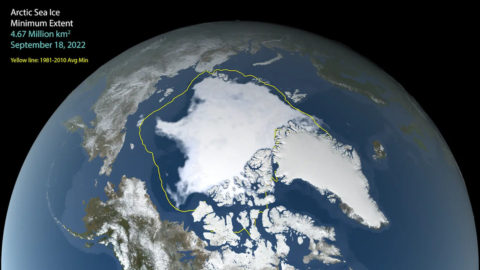
(3) A visualisation of the reduction of polar ice. Credit: NASA's Scientific Visualisation Studio
(4) The NASA and ISRO logos. Credit: NASA, ISRO
